Torrential Rain, Urban Environments, and Design
)

Since the unusually high temperatures in June this year to the rare torrential rains and floods in late July in the North China Plain caused by the influence of a typhoon, according to media reports, on July 29, the China Meteorological Administration issued the second red rainstorm warning in 12 years. The Beijing-Tianjin-Hebei region in the North China Plain experienced truly unprecedented heavy rainfall and flooding. Over the next few days, Beijing endured 90 consecutive hours of torrential rain, with a total rainfall equivalent to 306 West Lakes.
Frequent outbreaks of extreme weather have transformed the concept of the "climate crisis" from mere abstraction to a reality invading our daily lives in various forms such as floods, earthquakes, high temperatures, and droughts. What is more unsettling is that the disproportionate impact of climate change is falling on vulnerable groups, often the historically and systematically marginalized low-income communities.
Among these, floods are one of the most catastrophic natural disasters. Due to poverty, limited infrastructure, and restricted access to resources and healthcare services, flood losses in rural areas are more severe than in urban areas. The Indian state of Bihar, with a population of 104.1 million, sees 76% of its population regularly threatened by floods. In 2008, severe floods hit the northern regions of Bihar, affecting over 2.3 million people. In 2013, they impacted more than 5.9 million people in 20 rural areas and 3,768 villages. Floods damage property and infrastructure, further reducing opportunities to access healthcare and social services.
But why are we discussing the relationship between urban design and torrential rain floods today?
In the 1950s, some American scholars began to propose that urbanization increases the runoff of torrential rain within watersheds. The accelerated process of urbanization in recent years and inadequate or outdated rainwater infrastructure have turned rainwater into a crisis maker due to non-permeable hard surfaces replacing natural vegetation that can absorb rainwater. Any oversight can turn a heavy rainstorm into a torrent. Flood-prone villages become the first and hardest-hit "victims."
The pace of urbanization is even faster than we imagine. By 2035, it is expected that 70% of China's population will reside in urban areas, exerting tremendous pressure on urban infrastructure, local environments, and resources. The rapid pace of urbanization, along with related pollution and unsustainable building practices, has caused serious environmental and water-related issues in China.
Amid climate change, how can we prevent floods from becoming a new normal? How can we create a greener, more inclusive, and more resilient city by using risk-based urban design and innovative measures to adopt new methods to address flood risks? From the best management practices (BMP) and low-impact development (LID) in the United States to water-sensitive urban design (WSUD) in Australia, low-impact urban design and development (LIUDD) in New Zealand, integrated management of urban river basins in Japan, and more than ten years of sponge city practices in China... Every country is striving to change its urban water structure, and from these cases, we may be able to draw some experiences and gain inspiration.
Rotterdam: Shifting from Battling Water to Coexisting with It
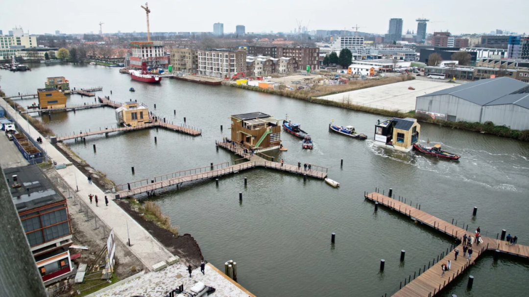
Since 2001, Rotterdam has been dedicated to transforming into a resilient delta city by reimagining its relationship with water. The city has devised a series of intricate plans to address not only flooding but also issues like drought and extreme heat due to climate impact. Some plans are vast, involving the entire city strategically, while others are targeted, allowing communities and individual households to participate. Among these initiatives, the most notable is the 'Floating City.'
Schoonschip, a new sustainable community in Amsterdam, aims to serve as a prototype for resilient cities by embracing a floating direction. Designed by the Dutch architectural firm Space&Matter, the project consists of 30 interconnected floating blocks, totaling 46 homes, equipped with dispersed and sustainable energy, water, and waste management systems.
Developing floating structures eliminates the need for extensive land preparation, excavation, or foundations. It preserves the original waterfront environment, ensuring that construction not only avoids ecological disruption and land competition with water but also adapts to rising water levels by floating, unaffected by environmental changes. This effectively enhances urban resilience and mitigates the impact of climate change.
Vietnam: Experiential Wisdom and Infrastructure Born from a Water-Centric Perspective
For water-rich yet vulnerable Vietnam, the water phenomenon is both abundant and highly destructive. The Red River and Mekong River deltas, situated at the polar ends of Vietnam, provide fertile lowlands for the majority of the population. The rural areas connecting them act as a natural funnel, receiving most rainfall from frequent typhoons that batter the mountainous terrain of Laos.
In the prolonged struggle against floods, Vietnam has accumulated rich but painful experience. To translate the wisdom of coexisting with floods into actionable urban design, Vietnamese researchers have articulated three principles: urban design should (1) predict and adapt to floods, (2) integrate flood ecological processes, and (3) disclose flood dynamics to the public. These principles complement existing urban design concepts.
Another lesson from Vietnam is about 'adaptation.' Floods are not static, and people need to learn to adjust, flexibly responding to various emergencies. This requires not only policy changes but also continuous updates in infrastructure:
The Yen Nghia project in southwestern Hanoi, initiated by the Ministry of Agriculture and Rural Development, marks the beginning of substantial flood prevention efforts. By the end of 2018, the country's largest flood pumping station would be constructed, serving approximately 6.4 million residents.

UK: Sustainable Urban Drainage Systems (SuDS)
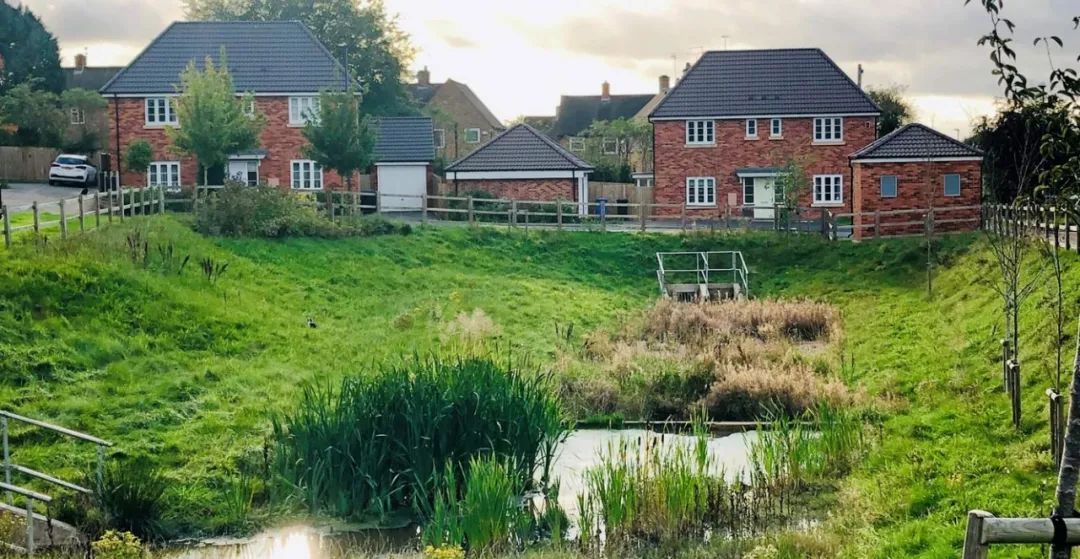
The concept of Sustainable Urban Drainage Systems (SuDS) emerged in the late 1980s in the UK. Designers questioned the sustainability of traditional piped drainage in urban environments, emphasizing the need for alternative solutions. While SuDS's primary purpose is to provide a nature-based drainage system that manages large runoff volumes, its application has brought broader benefits, including improved water quality, enhanced comfort, aesthetics, and biodiversity. Returning drainage to natural processes is a key goal of SuDS, achieved by reducing impervious surfaces.
SuDS installations in the UK typically focus on individual disconnected devices. However, combining these individual infrastructures creates an extensive chain, offering an accumulative approach to runoff management. SuDS concentrates on depressions rather than conveyance pipes, increasing opportunities for infiltration. Hamilton in Leicester, a 26-hectare new development built in 2003 on previously agricultural land, exemplifies SuDS in action. Using a network of ponds, vegetation ponds, filter strips, and basins, the site provides a more environmentally friendly and natural drainage method.
US: Low Impact Development (LID)
The term "Low Impact Development" (LID) refers to systems and practices in urban development that use or mimic natural processes, leading to rainwater infiltration, evaporation, or use, with a focus on protecting water quality and related aquatic habitats. LID adopts principles such as preserving and reconstructing natural landscape features to minimize effective imperviousness and create functional and attractive site drainage systems. The aim is to view rainwater as a resource rather than waste.
One of the earliest large-scale LID implementations in the US is the Somerset community in Prince George's County, Maryland. In 1995, developers successfully integrated LID technologies into a 60-acre development, featuring 199 houses on 10,000 square feet each. This alternative development pattern, using distributed stormwater management systems, added six additional lots, increasing revenue by $40,000 per lot, resulting in a total cost savings of $916,382. This success has made LID the most extensive application in the US, influencing subsequent implementation of sponge city plans in China.
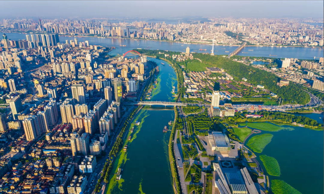
China: Sponge Cities
Since China first introduced the concept of "Sponge Cities" in 2012, the country has carried out numerous pilot projects. The performance evaluation reports of two batches of pilot cities in 2019 showed that 30 pilot cities had a total sponge city construction area of 920 square kilometers, with a total investment of around 160 billion yuan.
According to the 2014 "Technical Guidelines for Sponge City Construction" released by the Ministry of Housing and Urban-Rural Development, a sponge city is one that "can adapt to environmental changes and respond to natural disasters like a sponge. It can absorb, store, and infiltrate rainwater timely and release stored water when needed."
After the heavy rainfall in Zhengzhou, however, the concept of sponge cities faced widespread skepticism and became a focal point of public discussion.
Why couldn't sponge cities prevent large-scale flood disasters? On one hand, the implementation of sponge cities mainly follows a "top-down" approach, with the Ministry of Housing and Urban-Rural Development (MHURD), the Ministry of Finance (MOF), and the Ministry of Water Resources (MWR) setting national standards in 2014 for sponge city construction. These guidelines heavily reference low impact development practices in the United States, often leaning towards gray infrastructure. Due to China's late start in water system development and its vast geographic and climatic variations, local policies and governance need to be tailored to specific conditions, as overreliance on nationally standardized design without considering local climates might result in either overdesign or inadequate solutions, exacerbating water resource availability and/or flooding issues.
On the other hand, the strong rainfall in the Beijing-Tianjin-Hebei region in July was characterized by prolonged duration, substantial cumulative rainfall, and extreme intensity. According to reports, rainfall in major Hebei cities was significant: Baoding 350 mm, Dingzhou 319.7 mm, Shijiazhuang 289.2 mm, Xiong'an New Area 261.3 mm, Handan 218.4 mm, Langfang 224.2 mm, and Xingtai 192 mm. Sponge cities have their 'shrinkage range,' and the current extreme weather events have far exceeded the scope these systems were designed to handle.
To better implement sponge cities, research is needed to understand the spatial distribution of rainfall in China. An increased network of rain gauges, especially in major cities, would aid in-depth-duration-frequency modeling to analyze differences in design standards storms among different regions. Integrating local conditions and climate characteristics (such as geology and evaporation rates) along with rainfall data can provide optimal solutions for stormwater management.